Darkest Hour - Dev Diary #23 - New Map 2.0 and Improved Logs
Follow us on:
![]()
![]()
We've already introduced our new Map back in Dev Diary 2, on September 20th 2010 (it feels like a lifetime ago!). Don't worry, we didn't decide to use another map, that's our map and we'll keep using it. To be more precise, we've made a few changes in these past few months (some thanks to your feedback), but it's only a few provinces here and there, nothing major. What we're going to introduce now is a new, innovative improvement to our map: we added topographic layers!
As you probably know, there are 4 zoom levels in Darkest Hour (between whose you can switch with the mouse cursor by the way). Here's what we've added:
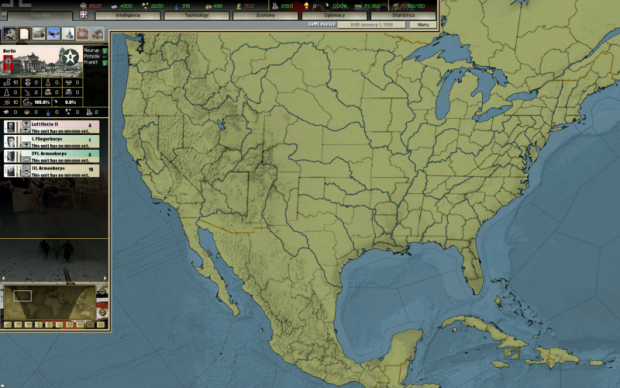
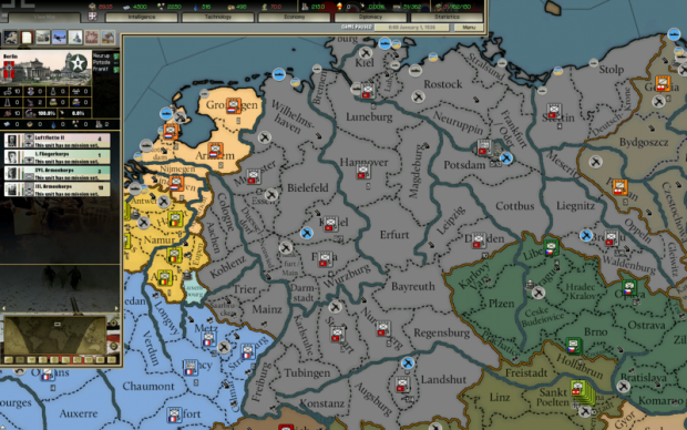
- Zoom level 1: this is the closer zoom level, no changes here;
- Zoom level 2: this level shows topographic ocean with plain land (so that province names can still be easily read);
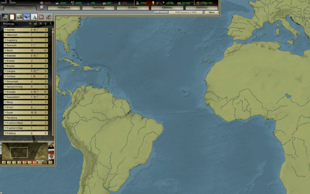
- Zoom level 3: this level show both topographic ocean and topographic land, with slightly wider country border and without black edge; the province names have been removed;
- Zoom level 4: this is the higher zoom level and shows both topographic ocean and topographic land, without both province and country borders;
I have been trying to get ewphoenix123 to tell us a bit more about the new map, but it became pretty obvious soon that what he can tell is probably too technical and boring for most of you. And if we cut it down then it won't be not detailed enough to satisfy those few out there that are interested in map modding.
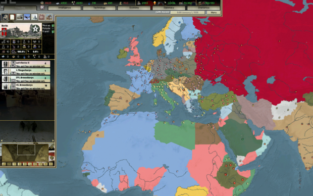
Therefore as images are worth more than words, here we go, a picture from each zoom level!
Zoom level 1
Zoom level 2
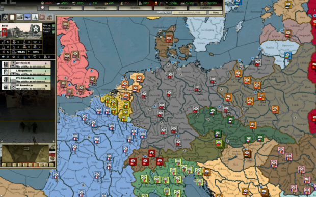
Zoom level 3
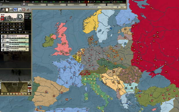
Zoom level 4
We're always working on improving Darkest Hour and we're happy to have been able to introduce this innovation since the release of DH! We hope you'll appreciate it! 
And now, on a lighter note, something that will be appreciated by a far more restricted crowd (which won't be disappointed anyway): Improved Logs.
We've added a new parameter in setting.cfg, which allows you to choose the level of debug written in the file savedebug.txt:
Level 0 is the default level used by the players: not a lot written at this stage, so gameplay won't be affected in any way.
Level 1 on the other hand will write a comprehensive list of information, but not many regarding the map. A decrease in performance can be noticed, so you should use this setting only to found problems or check for possible mistakes. It's very useful: for example thanks to this the Kaiserreich Team was able to find many wrong minister traits in their files, with a lot of misplaced ministers traits or ids. Here's an example on the kind of informations you can find here:
infantry ('db\units\divisions\infantry.txt'): 18 model(s) loaded (0 to 17).
...
}
Loading minister personalities...
The generic minister personality is loaded and set.
Loading minister personalities DONE. 103 personalities loaded.
Calculating minister personality values...{ ... }
Reading distances from map\map_1\airdist.tbl... Done! (2760 provinces read in 16 ms)
Reading map\map_1\navaldist2.tbl... Done! (1378 naval provinces, Read distances = 1898884)
Loading Ministers (Mods\Darkest Hour Full\db\ministers.txt)
{
Mods\Darkest Hour Full\db\ministers\ministers_afg.csv
...
}
Loading Leaders (Mods\Darkest Hour Full\db\leaders.txt)
{
Mods\Darkest Hour Full\db\leaders\afghanistan.csv
...
}
Parse events file: Mods\Darkest Hour Full\db\events\AI\AI_GER.txt...{
Loading event #3003001...
...
}
Scenario Validation (provinces)...Done. No errors found.
Loading Tech Teams (Mods\Darkest Hour Full\db\teams.txt)
{
Mods\Darkest Hour Full\db\tech\teams\teams_afg.csv
...
}
Processing (124) Decisions...
{
To Events (AI) (CHI): 'The Fading Sun' (2012004)
WARNING! Event'Produce Winter Equipment' (9000000) is set as DECISION, but has no COUNTRY!!!
...
}
{Used MP
Country;Dep. Land;Dep. Navy;Dep. Air;Dep. Total;Prod. Land;Prod. Navy;Prod Air;Prod. Total;MP Assigned Total;MP Pool;MP Total;
United Kingdom;157.38;121.25;3.88;282.51;0.00;12.55;0.00;12.55;295.06;20.00;315.06;
...
}
{Setting up Abyssinia
Setting Capital Abyssinia
Goverment Abyssinia
Military Scores - Total(Army/Air/Naval): 92.80(90.47/2.33/0.00) , Total IC: 3.00, Ratio = 31.03
units done
Setting up Abyssinia DONE
}
{Setting up Afghanistan
...
}
Obviously there are no errors reported (just a warning, but it's correct, don't be afraid!). 
But please trust us when we say that this will be a useful tool in tracking down problems and mistakes.
Level 2 of the improved logs contains all the information of level 1 plus a lot more regarding the map, starting with a detailed report on the connections and sea provinces assigned to each province:
{
#0 ((Embarked)) - 0:
#1 (Reykjavik) - 2:
;3;Akureyri
;2664;The Westman Islands
#2 (Torshavn) - 1:
;2676;Faroe Islands
#3 (Akureyri) - 3:
;1;Reykjavik
;2664;The Westman Islands
;2665;Grimsey Island
#4 (Stornoway) - 2:
;2716;The Hebrides
;6;Inverness
#5 (Scapa Flow) - 2:
;6;Inverness
;2685;Orkney Islands
#6 (Inverness) - 6:
;5;Scapa Flow
;7;Aberdeen
;8;Fort William
;2685;Orkney Islands
;2716;The Hebrides
;4;Stornoway
...
This is followed by a LIST PROVINCES BY CONTINENTS report, a LIST PROVINCES BY REGIONS report and a LIST PROVINCES BY AREAS report. No example here, their content is obvious.
After those, there is a report on WORLD RESOURCES:
Copy and paste to a new file and change its extension to CSV.
Open in Excel and sort by columns
;ID;Name;Area;Region;Continent;Controler;Owner;IC;MP;Oil;Metal;Energy;Rares;Infra;AirF;Port;LF;CF;AA;Radar;Rocket;Nuclear;
;1;Reykjavik;Iceland;Iceland;Europe;Denmark;Denmark;0.00;0;0.00;0.00;0.00;0.00;0.40;4.00;4.00;0.0;0.0;1.0;0.0;0.0;0.0;
...
}
After that, there is another report called MAP AND PROVINCES ANALYZING, which is focused on coordinates problems and will help you to track down errors in the province.csv like misplaced map icons or wrong seazones:
{
Province 1677 (Majuro) has Sea zone 2425 (Ratak Islands), but it is not adjacent. No suitable sea zone could be found!!!
}
Provinces with beach, bit without a sea zone (ERRORS)
{
}
Wrong City position coordinates (ERRORS)
{
Province 9 (Lerwick) has City coordinates set in 2684 (Shetland Islands).
}
Wrong AA position coordinates (ERRORS)
{
}
It also contains a list of provinces by number of connections and a list of land provinces with 6 to 8 connections (to check the Holy Rule, you know - see Dev Diary 2 if you don't remember what it is!). After that there are some reports on Distances to Neighbouring Provinces, divided by distance. Finding two neighbouring land provinces distant 1500 Km is probably (but not always) a mistake!
Finally, the map report is closed by a list of distances to all neighbouring provinces:
252 km - #3 (Akureyri)
46 km - #2664 (The Westman Islands)
#2 (Torshavn) - 1:
114 km - #2676 (Faroe Islands)
#3 (Akureyri) - 3:
252 km - #1 (Reykjavik)
235 km - #2664 (The Westman Islands)
132 km - #2665 (Grimsey Island)
#4 (Stornoway) - 2:
140 km - #2716 (The Hebrides)
152 km - #6 (Inverness)
...
No, wait, that's not all!
There is also a Provinces Climate Analyzing report, that checks and suggest climates for each province!
This is really the end, no more reports! Some of you may be bored, but the modders out there will appreciate it and will use it to improve their mods, so even the casual player can benefit from this.
And to close this DD, here are other pictures from the new map (zoom level 3 and 4 respectively):